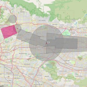
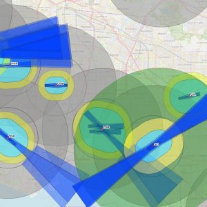
We’re excited to introduce a powerful new feature in Airspace, the Airspace Map! This mapping tool graphically displays critical areas defined by Title 14 CFR Part 77, including notice criteria, obstruction standards, near airport VFR protection areas, and navaid boundary zones. We’ve also added offset instrument procedure and special instrument procedure (private) notice areas that are protected by the FAA but are not captured by Part 77 criteria. With this enhanced visualization, you’ll gain better situational awareness, making it easier than ever to analyze airspace constraints and make informed decisions. Explore boundaries, assess potential impacts, and plan with confidence – all in one application.
We’ve also added additional features to Airspace to improve your analysis workflow. The “Get Elevation” feature is designed to automatically get the site elevation of a latitude/longitude point. The source of the elevation data is displayed underneath for reference. The primary data sources are NationalMap.gov Elevation Point Query Service and Google Maps Elevation Service.
The last feature is the addition of a map icon that is in the analysis panel. You can now set a new study point directly from the map. Simply click the map icon and then click the desired location on the Airspace Map. The application will get latitude/longitude coordinates automatically and update the analysis pane.
Take your airspace analysis to the next level with these powerful new features. Start exploring!
News
Updates related to:
- Airspace® and TERPS® software
If you have any questions or concerns, please give our office a call at (321) 777-1266, or send us an email, airspace@airspaceusa.com, we would be happy to assist you.


