- January 19, 2011
- Posted by: Airspace USA
- Category: Airspace, FAA, News, TERPS

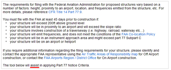
FAA Notice Criteria Tool implementing new changes to FAR Part 77 ***USERS BEWARE***
January 18, 2011 the Federal Register published a revision to Title 14 CFR Part 77, effective 18 January 2011. Previously entitled Objects Affecting Navigable Airspace, Part 77 is now called Safe, Efficient Use and Preservation of the Navigable Airspace. The new Part 77 provides less guidance than ever before regarding the requirements to notify the FAA of proposed and existing structures that may affect the safety and integrity of the National Airspace System (NAS).
With changes to Part 77 come changes to the FAA OE/AAA’s online “Notice Criteria Tool” (NCT). The latest inception of the NCT does not account for Instrument Flight Rule (IFR) Effects as notice requirements; IFR notice requirements previously defined by 77.13(a)(4) are conspicuously absent from the new Part 77.
Users beware: NCT output stating that notice is NOT required does not necessarily mean that a structure does not require notice to the FAA or FCC. In fact, the arms of the law are longer than ever, as notice must be filed “when requested by the FAA” (77.9). How the FAA purports to make such a request is unknown.
Last year, FA&A observed an anomaly that caused the NCT to be out of service for an extended period of time – the NCT was not requiring notice for structures off airport property that were directly in line with a runway. This was due to deficiencies in the FAA’s runway database.
Similarly, yesterday’s release of the NCT introduced more examples of the NCT’s failure to require notice for structures that clearly impact the aeronautical environment. Now the NCT does not require notice for 199’ structures just feet away from a Air Navigation Facility, such as a VOR or ARSR facility. While last year’s anomaly could be remedied by updating a database, this new problem is far more complex. Like the new Part 77, the NCT does not protect critical NAVAID (navigational aid) facilities and offset instrument procedure areas.
We have studied the output of the new Notice Criteria Tool and made the following observations:
- NCT fails to require notice when proposed construction is near a critical air navigation facility.
- NCT fails to require notice when proposed construction is clearly within an offset instrument procedure area.
When the FAA does not require notice, although it clearly should (as in Example 1), structures may be constructed that nullify instrument procedures or air-ground communication by blocking the signal from a VOR/VORTAC/TACAN/NDB or ARSR facility. If a structure, such as a communications tower, renders a NAVAID or radar facility inoperable, the facility owner (FAA or DoD) will investigate the area and discover that an obstruction has been erected without notification to the FAA. Failure of an online tool to require notice does not remove the tower owner’s responsibility to ensure that the FAA be notified of the tower. Therefore, allowing the NCT to determine when to file notice does not constitute due diligence.
Part 77 itself does not reference the NCT, and NCT anomalies and deficiencies cannot shield structure proponents from liabilities should a structure cause an aviation incident. In fact, the NCT offers the following disclaimer:
This language clearly relieves the NCT of responsibility to provide an accurate and complete summary of notice requirements for any given site.
Our attempts to determine precisely how the requirements vary were thwarted by the vague catch-all of 77.9: “Notice to the FAA is required…If requested by the FAA”.
Remember: The tool assists in applying Part 77 Notice Criteria. Whether or not a structure is in compliance with Federal Aviation Regulations must not become a matter of semantics. Airspace® and TERPS® software provide numerical answers.
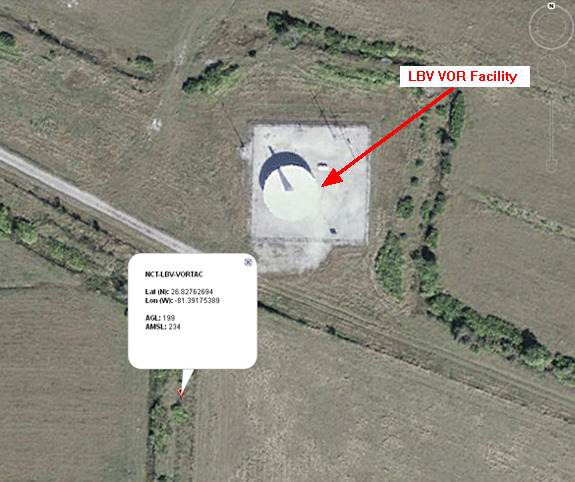
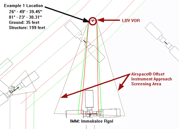
Example 1 – FAA NCT Fails To Require Notice For EMI Impact
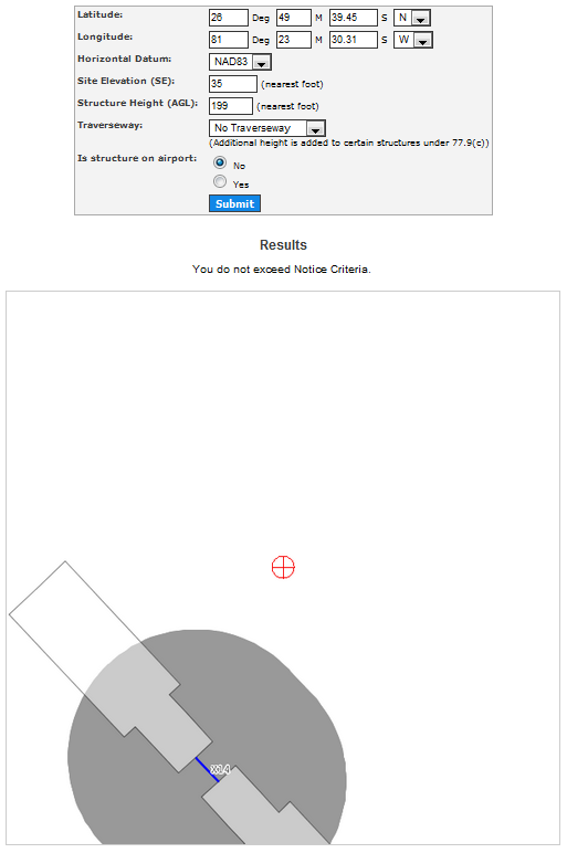
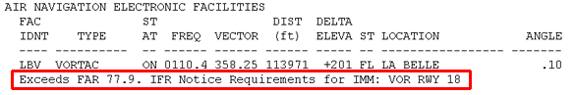
This location is 229’ from the LBV VORTAC. It is expected that a 199’ AGL structure would significantly compromise the VORTAC signal and disrupt Airways and Instrument Approach Procedures. Once this is reported to the FAA, they will determine a tower has been constructed. The FAA will seek out the proponent and verbally request the tower owner file notice with the FAA. The FAA will study the tower as an existing structure and will issue a Determination of Hazard. Additionally, the FAA will contact the FCC, who will investigate the complaint. The FCC will issue a fine to the tower owner and make the tower owner dismantle the tower.
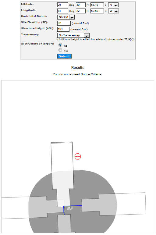
An analysis of the same coordinates, structure height and ground elevation was conducted using FA&A’s Airspace OMS Software, which yielded dramatically different results and alerted the user of a potential high level conflict with the LBV VORTAC.
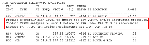
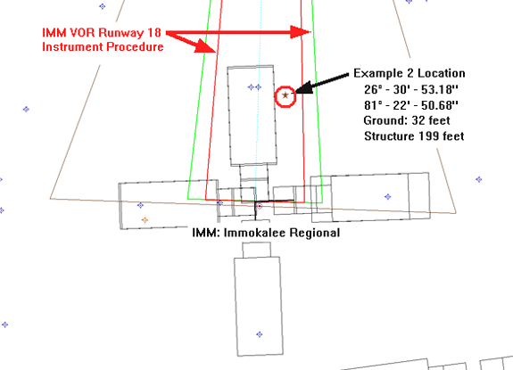
The Airspace Analysis Summary Report contains a section on Air Navigation Electronic Facilities. The summary analysis correctly predicts that the proposed tower would have a high level of impact on the LBV VORTAC and Notice to the FAA is recommended. It also states that the proposed location is contained within an instrument procedure area for IMM VOR Runway 18.
This TERPS® image clearly shows that there is every reason to file notice of the proposed structure with the FAA and to expect that the proposed structure will have an adverse impact on aviation and will receive a Determination of Hazard from the FAA. Nonetheless, the NCT states “You do not exceed Notice Criteria.”
The liability for any aviation incident that occurs as a result of loss of signal with the VORTAC will fall on the shoulders of the structure proponent. It is crucial to document the exact nature of the relationship between a proposed structure and the aeronautical environment before construction. TERPS® images provide time-stamped snapshots of the aeronautical environment. Coupling Airspace® Summary Report Output with TERPS® drawing tools provides a powerful and accurate rendering of the complete aeronautical environment.
Example 2 – FAA NCT Fails To Require Notice For Offset Instrument Procedure
This location is greater than 20,000’ from the nearest runway at IMM (Immokalee Regional Airport) and beyond the requirements of the new 77.9(b) (same as old 77.13(a)(2)).
FAA NCT places Example 2 outside of their straight-in RNAV IFR Tool Area and beyond the range of 77.9(b) with the results “You do not exceed Notice Criteria”. However, The NCT is in error because the Example 2 is located inside the IMM VOR Instrument Procedure and therefore Notice should be required.
An analysis of the same coordinates, structure height and ground elevation was conducted using FA&A’s Airspace® OMS Software which yielded dramatically different results and alerted the user that the study point was located within the IMM: VOR RWY 18 procedure area shown above and Notice to the FAA should be made. The outcome of notifying the FAA would be a Determination of No Hazard and a request to file supplemental notice so that the structure could be charted.
This TERPS® image clearly shows that there is every reason to file notice of the proposed structure with the FAA because the site is located within an actively used instrument procedure. However, if constructed without notice to the FAA, there is no way the FAA will learn of the presence of the new structure. Without this knowledge the FAA will not be able to chart this structure and make its presence known to pilots. If an aviation incident should occur, the tower owner may be open to litigation.
Example 3 – FAA NCT Fails To Require Notice Of Structure Being A Hazard To Air Navigation
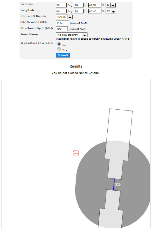
In this example, the NCT states, “You do not exceed Notice Criteria.” The problem with this result is that there is an actual penetration to an IFR Surface. The FAA’s NCT does not identify any IFR issues.
The Airspace® Summary Report under Air Navigation Electronic Facilities section identifies the exact nature of the problem.
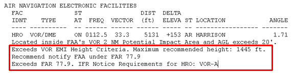
Airspace® identifies two specific problem areas: One is a potential Electromagnetic Interference problem that may impact the HRO VOR itself. The other is a potential impact to the HRO (Boone County Airport) VOR-A Instrument procedure to the airport.
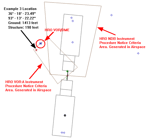
The TERPS® Image shown above is a graphical representation of the Notice Areas that the Airspace® software calculates when determining if a Study Point is located within an Offset or Straight-In Instrument Approach Procedure. When a Study Point is located within one of these areas, Airspace® will display the alert as a message in the Quick Results Window as red text. Users of the Airspace® software can also review this in the AIR NAVIGATION ELECTRONIC FACILITIES section of Summary Report.
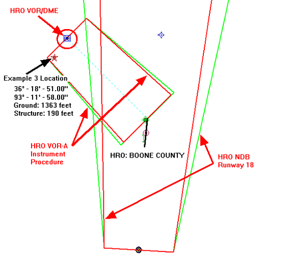
The image below is the TERPS® image of the VOR-A and NDB Runway 18 Instrument Procedure Areas that are protected. Please compare the TERPS® Image displaying the Notice Criteria shown above with the TERPS® Image showing the actual instrument procedures shown below. You will find these areas to be very similar. We have been busy coding to ensure that our Airspace® software users are always alerted when their Study Point is within an Offset Instrument Procedure Area and Notice to the FAA is required.
An important point to note is that the AGL height of the proposed tower is 190 feet, therefore notice would not be required under Part 77.9(a) (formerly 77.13(a)(1)). However, the proponent would be unaware of its potential impact to the HRO: Boone County Airport VOR-A procedure, especially if the FAA’s NCT was the only tool used to determine if notice was required.
Scenario 1: Proponent does not file.
If the proponent accepts the results of the NCT and does not file with the FAA, the proposed structure would be violating the Required Obstacle Clearance of the HRO VOR-A procedure. The maximum allowable height under this procedure is 1530’ AMSL. The proposed structure is 1603’ AMSL and penetrates into protected airspace by 73’. Should an aviation incident occur, the tower owner would be 100% liable.
Scenario 2: Proponent Files Notice with the FAA.
The NCT analysis results stated that there was no requirement, but just to be sure, the proponent decided to file notice without a survey. After a protracted amount of time, the FAA would have responded that the proposed structure exceeded the HRO VOR-A instrument procedure by 123’ (4D survey accuracy) and the Not To Exceed Height would be 67’ Above Ground Level (AGL), or 97’ AGL with a 2C survey. Having to reduce a 190’ proposed structure to 123’ AGL would likely cause difficulty for the proponent. Without the warning given by Airspace®, the proponent, unaware of any potential impact to this instrument procedure, might procure property and equipment and enter into service contracts.
These same examples can be applied to a multitude of structures throughout the country that impact a NAVAID or offset instrument procedure(s). Individuals relying solely on the NCT to determine whether or not to file notice with the FAA will not be able to make sound, well-informed business decisions and could face significant budgetary and legal repercussions based on the FAA’s online tool outputting responses in error.
The Airspace® software provides a clear view of the aeronautical environment so its users are always alerted and prepared.
If you have any questions or concerns, please give our office a call at (321) 777-1266, or send us an email, , we would be happy to assist you.